RFQ - Engineering Study for Dredging and Updated Information
The Port of Pittsburgh Commission is seeking qualifications for engineering, permitting, right-of-way, and utilities services to develop cost estimates for funding, and a construction bid package to dredge the ingress and egress at specific locations along the Monongahela River.
Ingress and egress for many river users along the shoreline between river mile 23.8 and 41.5 of the Monongahela has been impacted by the removal of the Elizabeth dam. Therefore, the PPC is interested to pursue developing a plan to adjust and/or restore access in specific locations for safe navigation from the shoreline to the official navigation channel.
This project is to assess the scope of dredging required to maintain a depth of 11 feet below the waterline in specified areas of the Monongahela River for ingress and egress. Qualified offerors should request the full RFQ document by sending an email to: matt@portpitt.com
Update: Information for Lower Mon RFQ (As of 2/13/15)
RFQ Q&A recording (Monday, 2/10/25, 24mins):
PortPITT RFQ Virtual Meeting (Q&A)-20250210_103443-Meeting Recording.mp4
PPC's response to questions asked during virtual meeting:
RE: Lower Monongahela River project: Ingress & Egress Q & A
February 10, 2025
Qualifications:
PPC is interested to review qualifications only from interested firms or groups of firms to evaluate for selection. Cost or price information is not to be provided at this time.
Areas to be Dredged:
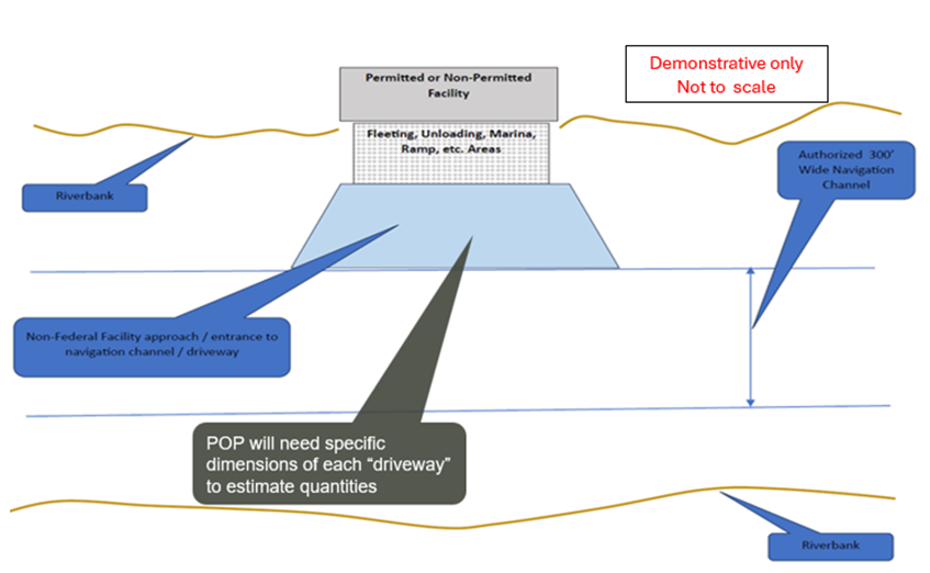
Some property owners have facilities that were impacted by the change in river water levels and dredging will be needed to reestablish their accessibility to the river navigation channel. PPC is interested to assure that selected property owners are provided a safe, dredged channel if they meet criteria that will be established through the course of this project. USACE Pittsburgh District is dredging the ‘official navigation channel'. USACE is also working with industries along the river to identify some additional areas along the channel that likely need to be dredged to provide widening that will improve mariners’ maneuverability. PPC recognizes that some property owners along the shore line may need to amend their individual permits to include the entire access area to tie-in to the USACE official and widened navigation channel. PPC refers to those areas as ‘driveways’. PPC refers to the access areas that are not yet permitted as ‘no man’s land’ meaning the area is not included in USACE’s work plan, nor is it included in the property owner’s existing permit.
The PPC is not able to estimate the number of ‘driveways’ nor the extent of ‘no man’s land’ dimensions or configurations at this time. The shape, dimensions, and configuration of areas to be dredged will need to be determined on a case-by-case basis by the selected engineers in consultation w PPC and the property owners. Hence, a dredging construction project area is not yet defined. The selected engineer and PPC will work together to determine the ‘official project area’ in consultation with USACE and other resource agencies.
The USACE has received an environmental clearance from federal and state agencies for their dredging that is taking place currently as they establish a navigation channel in the Monongahela River. It will need to be determined if any part of the USACE’s environmental studies or approvals can be applicable for permitting the ‘driveways’ or ‘no-man’s land’ areas for this project. To date the PPC has not conducted any testing or environmental evaluations for ‘driveways’ or ‘no man’s land’ dredging or disposal areas. The selected engineering firm will be responsible to establish a plan for all necessary permitting approvals, including permittee and obligations in consultation with PPC.
The USACE has committed to provide to PPC the hydrographic survey data and contours that they have developed following the completion of their dredging operations. The PPC is not able to determine if this information is sufficient for this project at this time.
Lower Mon “Driveways” dredging graphic (Provided by the USACE. Graphic is not to scale. For visual representation only.)